Le Bois du Truc circuit (no. 12)
La Roche-de-Rame
Le Bois du Truc circuit (no. 12)
3h
23km
+1644m
-1644m
Loop
Embed this item to access it offline
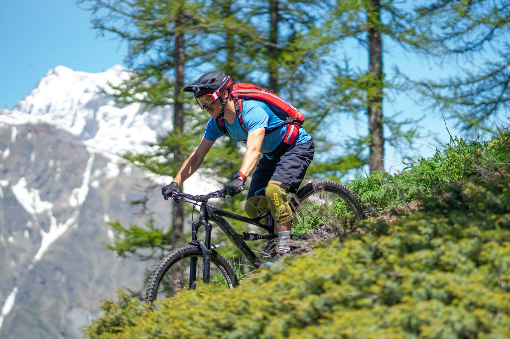
Circuit running above La Roche-de-Rame, along almost its entire length offering a panoramic view over the Durance valley and the municipality. As you ascend, Mont Pelvoux comes into view in the distance. The ascent is relatively straightforward along a wide track, although the descent is much more technical with a number of narrow single-tracks.
Description
The circuit starts not far from the La Roche-de-Rame mayor's office ("Mairie") near the Bouchouse mountain stream. First, follow its left-hand bank, going upstream. 430 metres further up, cross the mountain stream and carry on along the right-hand bank. At the crossroads, turn right to cross the mountain stream again and carry on uphill towards Bel Pinet.
- Turn left towards Le Lauzet, winding uphill along a stony track
- When you reach Bel Pinet, at 1,400 m altitude, take the track on the left to the Calvary and the Bois du Truc
- 150 metres past the Calvary, at 1,561 m altitude, turn left to the Bois du Truc up a final short ascent
- 180 metres further on, at a set of gate posts, turn left onto the path below the track, to tackle the single-track descent (Caution! Quite steep downhill section to reach the path, and technical stretches on the path)
- At the Bois du Truc, at 1,510 m altitude, carry on down the single-track section towards Le Bathéou and La Roche-de-Rame (exercise caution on the numerous technical stretches)
- At Le Mas des Ducs, at 1,290 m altitude, carry on straight ahead towards Bathéou and La Roche-de-Rame
- Continue straight ahead along the track above Le Bathéou, heading towards Les Gillis and the dwellings
- At Les Gillis, turn left onto the D338. Then, 60 metres further on, turn left again to the village centre
- Turn right and follow the Bouchouse downstream on the right-hand bank. Then, after 170 metres cross the mountain stream, which brings you back to the mayor's office and your starting point
- Departure : La Roche-de-Rame mayor's office ("Mairie")
- Arrival : La Roche-de-Rame mayor's office ("Mairie")
- Towns crossed : La Roche-de-Rame
Forecast
Altimetric profile
Recommandations
Rescue services contact details: Secours Montagne(Mountain Rescue): +33 (0)4 92 22 22 22 or 112
Take your litter home
Do not take shortcuts across pasturelandTransport
Public transport >> www.pacamobilite.fr
Consider car-sharing >> www.blablacar.fr
Access and parking
6.7 km from L'Argentière-La Bessée, take the N94.
Parking :
mayor's office ("Mairie") car park, La Roche-de-Rame
Source
Pays des Ecrinshttps://www.paysdesecrins.com
Report a problem or an error
If you have found an error on this page or if you have noticed any problems during your hike, please report them to us here: