VTT N°55 - The lime kilns
Through a landscape of chestnut and beech trees, ascend to the Causse Bégon plateau, on the western edge of the Cévennes mountains, enjoying exceptional panoramic views of the Dourbie canyon . This challenging route, with its significant elevation gain, is punctuated by heritage sites that invite you to stop and explore: lime and calamine kilns, the Baumelle sheepfold, and the dolmen called 'le Tombeau du Géant" (Giant's Tomb)
Description
- From the parking area, take Rue du Moulin to the old bridge (Pont vieux), then turn right onto Rue de Cabrune. At the crossroads, continue straight ahead on this road until you reach the last houses.
- Take the dirt track for 1 km (the climb is quite steep) until you reach the road that leads up to the Col de la Pierre Plantée (D341).
- Follow it to the left, then turn right onto a very nice singletrack (the climb is just as steep as the previous one). At the next intersection with the D341, continue to your right for approximately 250 m.
- Take the path at the hairpin bend and pass by an old lime kiln. Don't hesitate to stop and take a look. Continue the climb for another 2km to reach the intersection of the road heading towards Causse Bégon and a dirt track that branches off to the left.
- Follow the track for 3km. Two points of interest are located near the path: the Giant's Tomb (dolmen) and a rock shelter.
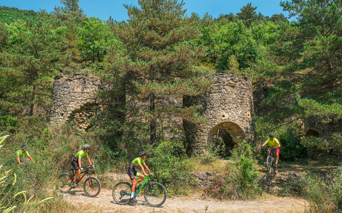
- Just before the rock shelter, turn left and descend onto a singletrack trail leading to Seingleys. Before the end of the descent, on the left, admire the four magnificent Valettes kilns (former calamine kilns).
- In Seingleys, follow the road to the left towards St-Jean du Bruel, then at the entrance to the village, turn right onto Rue du Pont Vieux to reach the parking area.
- Departure : St-Jean du Bruel
- Arrival : St-Jean du Bruel
- Towns crossed : Saint-Jean-du-Bruel and Causse-Bégon
Forecast
Altimetric profile
Recommandations
Very difficult route for e-MTBs (carrying required)
Transport
To travel by bus or train, by carpooling and hitchhiking Rezopouce.
Access and parking
40km southeast of Millau via the D809 and D999 (Larzac Plateau) or via the D991 and D999 (Gorges of the Dourbie).
Parking :
Accessibility
- Emergency number :
- 114


Report a problem or an error
If you have found an error on this page or if you have noticed any problems during your hike, please report them to us here: