Réallon - Embrun (TSP Gravel)
Réallon
Réallon - Embrun (TSP Gravel)
2h45
36,2km
+1614m
-2217m
Embed this item to access it offline
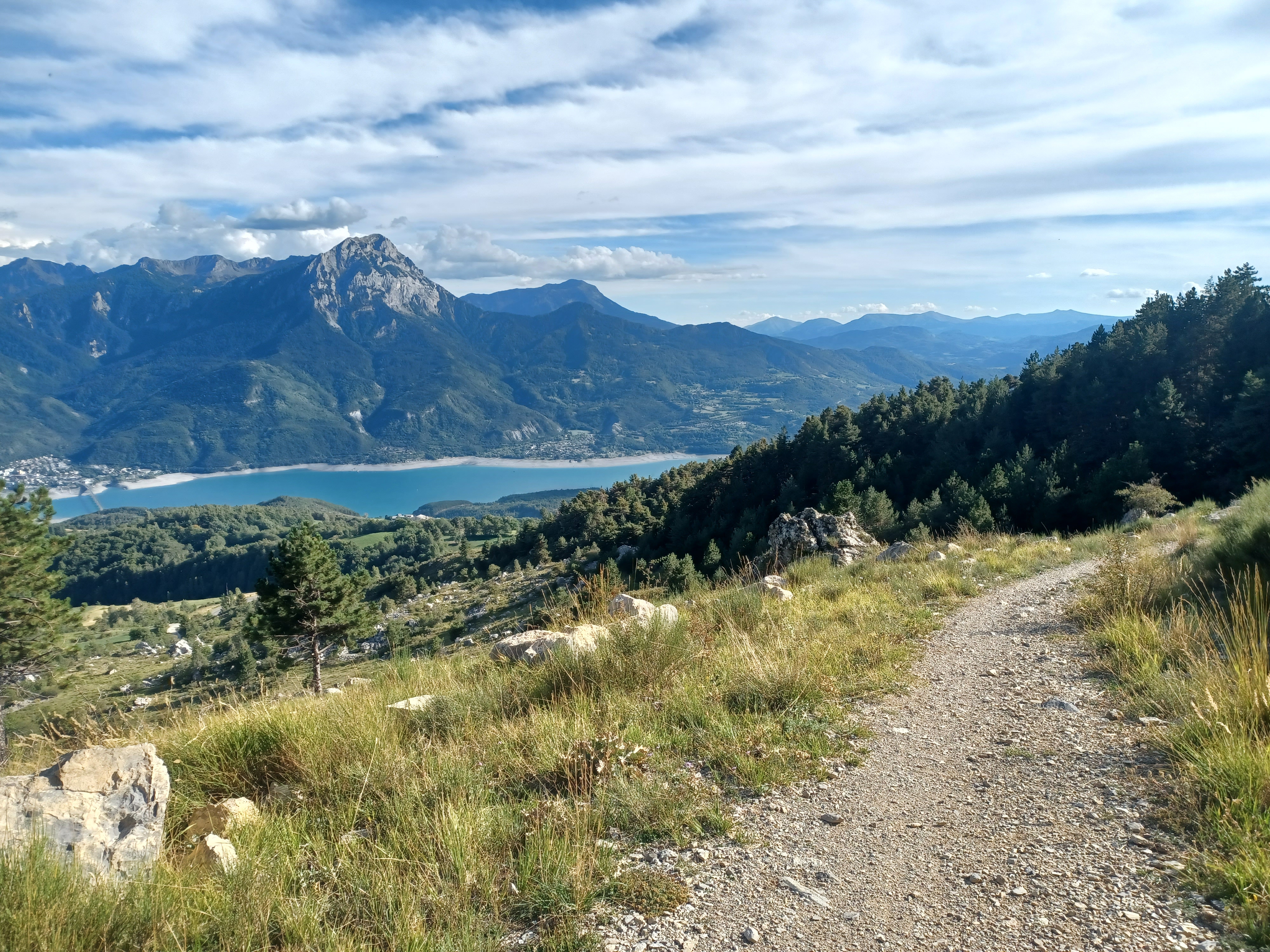
The final section sums up the tour: beautiful, rolling DFCI tracks, interspersed with stretches of mountain gravel and exceptional panoramic views. The most demanding ascent will be rewarded with one of the most beautiful balconies of this trip on the slopes of Mont Guillaume: the Chemin de la Baume.
Description
1) Turn right at Le Mélézin restaurant. After the bridge, turn right onto the road and then the track. Stay on the left bank and as close as possible to the stream as far as the Iscle leisure centre. At the Cure bridge, stay on the left-hand road towards Réallon.
2) At the road, turn right and then left to stay on the GR. Cross the Villard bridge to the right and head along the right bank. At "Côte Garcine", turn left towards the stream and ascend to Réallon. At the road, cross the village to the right.
3) After the Réallon village exit sign, leave the D41, take the left-hand track and then the first right onto the GR signposted path.
4) In the hamlet of Méans (Charrière des Touisses), turn left onto the small road towards Puy-Sanières Embrun (GR50). At the track, turn left. At the Reyssas stream, push the bike for 100m (steep, stony section)
5) At the chemin de la Baume, take the carriageway to the right. At the bend in the DFCI G1 track, turn left and stay on the main track to reach the "Porte de la Forêt" via the Lookout of La Para. (DFCI G1)
6) At the Porte de la Forêt car park, turn left onto the route forestière des Fontainiers. At the Route forestière du Bosquet, keep right (DFCI track G82).
7) Before the steep climb, take the path on the right towards Châteauroux 9 km. /!\ Quite a steep descent. Turn right at the path under the larches. Stay on the main road until you reach the hairpin /!\ watch your speed. Return journey possible as far as Châteauroux les Alpes (where accommodation is available) by turning left (follow route no. 53)
8) /!\ watch your speed: at the hairpin turn right and take 2 left turns on the less steep options. Then turn right at the edge of the wood onto the path on the right, which is carpeted with pine needles. (/!\ Several short sections with roots and stones).
9) After the houses, continue to the right on the less visible flat track. Above Les Barthelons, descend to the left, then take the first right onto the road. After the hamlet, turn left towards Embrun centre.
10) /!\ Slow down and turn left onto Chemin du Pigeonnier. /!\ Fast descent with waterways. At the end of the Chemin du Pigeonnier, turn left down the road to Embrun. Stay on the main road. Cross the railway line and take the 1st turning on the left to reach the SNCF station.
- Departure : Les Gourniers, Réallon
- Arrival : Embrun
- Towns crossed : Réallon, Puy-Saint-Eusèbe, Puy-Sanières, Embrun, and Châteauroux-les-Alpes
Forecast
Altimetric profile
Sensitive areas
Along your trek, you will go through sensitive areas related to the presence of a specific species or environment. In these areas, an appropriate behaviour allows to contribute to their preservation. For detailed information, specific forms are accessible for each area.
Short-toed snake eagle
- Impacted practices:
- Aerial,
- Sensitivity periods:
- MarAprMayJunJulAugSep
- Contact:
- Parc National des Écrins
Julien Charron
julien.charron@ecrins-parcnational.fr
Recommandations
Avant de partir vérifiez l’état de votre vélo, surveillez la météo et équipez vous selon la saison et la durée de votre randonnée.
Vous évoluez en zone de montagne, privilégiez des pneus de Gravel large, des freins à disque hydraulique et maitrisez votre vitesse.
Prudence dans la descente du Hameau de Vière et pour rejoindre la vallée de la Durance.
Pour plus de confort faites appel à un moniteur de cyclisme
Secours : 112
Vous évoluez en zone de montagne, privilégiez des pneus de Gravel large, des freins à disque hydraulique et maitrisez votre vitesse.
Prudence dans la descente du Hameau de Vière et pour rejoindre la vallée de la Durance.
Pour plus de confort faites appel à un moniteur de cyclisme
Secours : 112
Transport
SNCF: Chorges station, Embrun https://www.sncf-connect.com/
Bus : Valserres, La Bâtie Neuve, Chorges, Puy Saint Eusèbe, Puy Sanières, Embrun Baratier, Les Orres, Remollon, Theus, Espinasse
Marseille-Briançon : (LER29)
Marseille, Nice : Lignes Express Régionales (LER) +33 (0)809 400 415
Grenoble : Transisère +33 (0)4 26 16 38 38
Gap-Barcelonnette (LER535)
Carpooling area : Rond point des Orres - 05200 Baratier
Plane:
Marseille Provence Airport (188km) - +33 (0)820 811 414
Grenoble Alpes Isère Airport (158km) - +33 (0)4 76 65 48 48
Lyon Saint Exupéry Airport - (203km) +33 (0)826 800 826
Turin Caselle Airport - (178km) + 39 011 567 63 86
Access and parking
From Grenoble, Lyon, Paris : RN 85 or RN 75. At Gap, take the RN 94 towards Briançon.
From Marseille, Montpellier A51 to La Saulce, continue towards Tallard (D942) and Briançon (RN 94).
From Marseille, Montpellier A51 to La Saulce, continue towards Tallard (D942) and Briançon (RN 94).
Source

Serre-Ponçonhttps://www.serreponcon.com
Report a problem or an error
If you have found an error on this page or if you have noticed any problems during your hike, please report them to us here: