Loop 52 - The Balconies of Mont Guillaume
Embrun
Loop 52 - The Balconies of Mont Guillaume
3h15
38,9km
+1820m
-1820m
Loop
Embed this item to access it offline
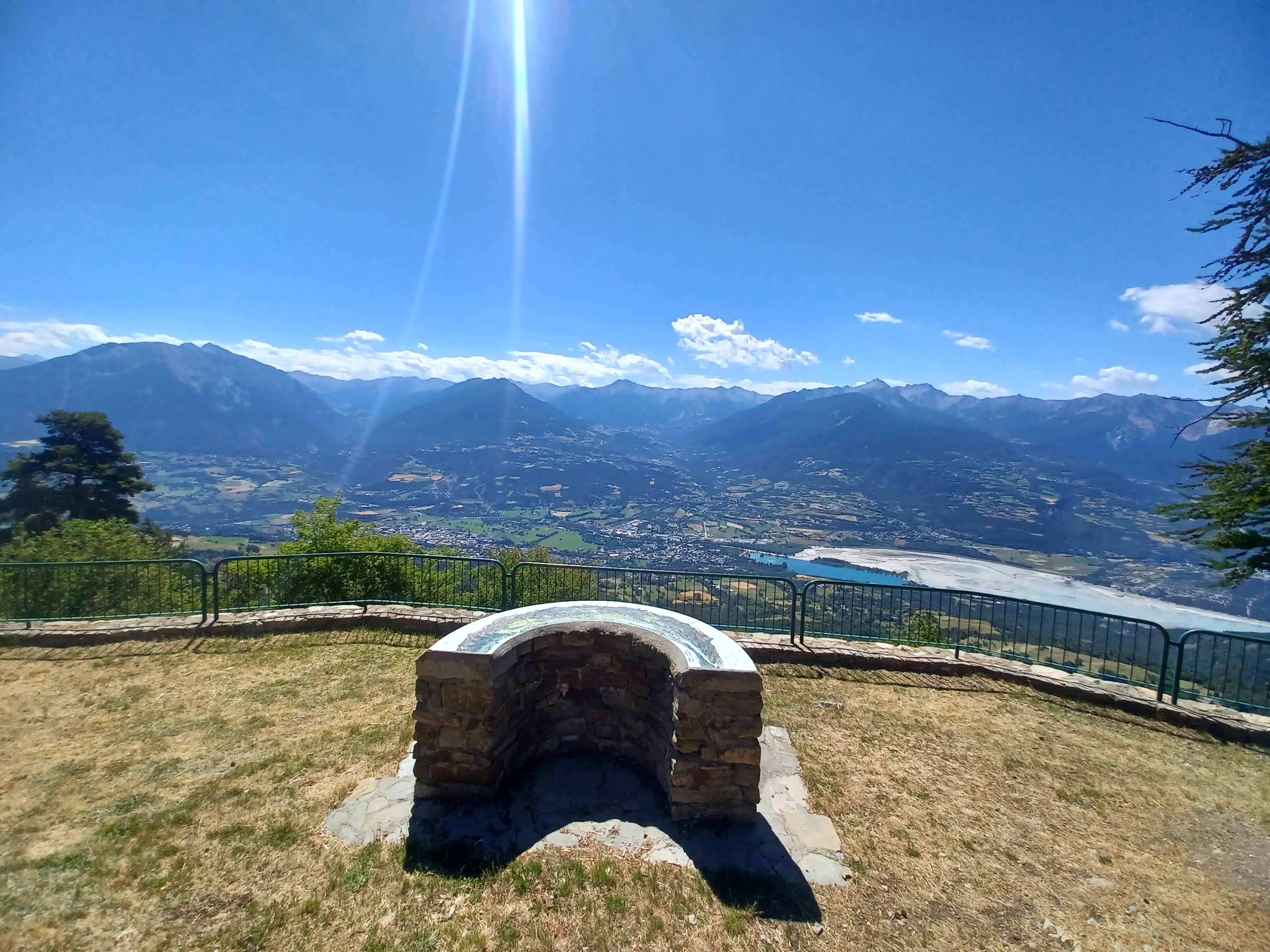
After a warm-up along the lake, there is a steady climb towards Les Puy as you reach the balconies of Mont Guillaume and the lookout point at La Para (ideal for a picnic break). The final stretch: a long descent on tracks and roads.
Description
- At the start of the mountain bike circuits, join the dam and follow it to the right. After the Club Nautique Alpin, follow the road to the left towards the Chadenas holiday park. Then continue up the main winding path. (/!\ Please close the fence)
- At the bus stop, follow the route des Puy to the left (D9) and climb to the right towards Serres (D309). At the fountain, continue up a hairpin bend to the left.
- At the bend, turn left onto DFCI track G2 (Viewpoint). Continue straight ahead on the main track to join the Route des Puys (D9). Follow it to the right.
- At Puy Saint-Eusèbe, turn right up the Route de l'Eglise (D309a).
- Leave the road for the Chemin des Clauséards on the right (DFCI G1) towards Embrun via the Lookout of la Para. At the crow's feet intersection continue along the track to the left. Stay on the main track until you reach the Piste de la Baume.
- At the route forestière de la Baume, continue uphill to the right (DFCI G1). Stay on this track and enjoy the view from the Para lookout. Continue straight on until you reach the car park.
- At the Porte de la Forêt car park, turn left onto the route forestière des Fontainiers. At the Route forestière du Bosquet, keep right (DFCI track G82). Before the steep climb, take the path on the right towards Châteauroux, 9 km. /!\ Quite a steep descent. When you reach the path under the larches, turn right. Stay on the main road until you reach the hairpin, then /!\ watch your speed.
- /!\ slow down: at the hairpin descend to the right and take two left turns down the less steep options. Then turn right at the edge of the wood onto the path on the right, which is carpeted with pine needles. (/!\ Several short sections with roots and stones). After the houses, continue to the right on the less visible flat track. Above Les Barthelons, descend to the left, then take the first right onto the road. After the hamlet, turn left down the road towards the centre of Embrun. (D465)
- At the Station, join the roundabout. Turn right and then slightly left onto the pedestrianised street towards the tourist office. At the end of the road, turn right and cross the supermarket car park on your left. At the end of the supermarket car park in Les Moulineaux, head down a small tarmac path towards the lake. /!\ steep path, tight bends and the lower part has a few stones. At the Chaffal turn right and then left to reach the dam. The lake is on your right.
- Departure : Embrun
- Arrival : Embrun
- Towns crossed : Embrun, Puy-Sanières, Puy-Saint-Eusèbe, and Châteauroux-les-Alpes
Forecast
Altimetric profile
Sensitive areas
Along your trek, you will go through sensitive areas related to the presence of a specific species or environment. In these areas, an appropriate behaviour allows to contribute to their preservation. For detailed information, specific forms are accessible for each area.
Short-toed snake eagle
- Impacted practices:
- Aerial,
- Sensitivity periods:
- MarAprMayJunJulAugSep
- Contact:
- Parc National des Écrins
Julien Charron
julien.charron@ecrins-parcnational.fr
Short-toed snake eagle
- Impacted practices:
- Aerial,
- Sensitivity periods:
- MarAprMayJunJulAugSep
- Contact:
- Parc National des Écrins
Julien Charron
julien.charron@ecrins-parcnational.fr
Short-toed snake eagle
- Impacted practices:
- Aerial,
- Sensitivity periods:
- MarAprMayJunJulAugSep
- Contact:
- Parc National des Écrins
Julien Charron
julien.charron@ecrins-parcnational.fr
Recommandations
Avant de partir vérifiez l’état de votre vélo, surveillez la météo et équipez vous selon la saison et la durée de votre randonnée.
Vous évoluez en zone de montagne, privilégiez des pneus de Gravel large, des freins à disque hydraulique et maitrisez votre vitesse.
Prudence dans la descente du Hameau de Vière et pour rejoindre la vallée de la Durance.
Pour plus de confort faites appel à un moniteur de cyclisme
Secours : 112
Vous évoluez en zone de montagne, privilégiez des pneus de Gravel large, des freins à disque hydraulique et maitrisez votre vitesse.
Prudence dans la descente du Hameau de Vière et pour rejoindre la vallée de la Durance.
Pour plus de confort faites appel à un moniteur de cyclisme
Secours : 112
Transport
SNCF: Chorges station, Embrun https://www.sncf-connect.com/
Bus : Valserres, La Bâtie Neuve, Chorges, Puy Saint Eusèbe, Puy Sanières, Embrun Baratier, Les Orres, Remollon, Theus, Espinasse
Marseille-Briançon : (LER29)
Marseille, Nice : Lignes Express Régionales (LER) +33 (0)809 400 415
Grenoble : Transisère +33 (0)4 26 16 38 38
Gap-Barcelonnette (LER535)
Carpooling area : Rond point des Orres - 05200 Baratier
Plane:
Marseille Provence Airport (188km) - +33 (0)820 811 414
Grenoble Alpes Isère Airport (158km) - +33 (0)4 76 65 48 48
Lyon Saint Exupéry Airport - (203km) +33 (0)826 800 826
Turin Caselle Airport - (178km) + 39 011 567 63 71
Access and parking
From Grenoble, Lyon, Paris : RN 85 or RN 75. At Gap, take the RN 94 towards Briançon.
From Marseille, Montpellier A51 to La Saulce, continue towards Tallard (D942) and Briançon (RN 94).
From Marseille, Montpellier A51 to La Saulce, continue towards Tallard (D942) and Briançon (RN 94).
Parking :
Embrun lake car park
Source

Serre-Ponçonhttps://www.serreponcon.com
Report a problem or an error
If you have found an error on this page or if you have noticed any problems during your hike, please report them to us here: